Aerial images provide perspective on how the Ventura River responds to flood. The wide floodplain is typical of high sediment yield watersheds, featuring braided channels that shift with each major flood event. The flood of January 9, 2023 ripped out large areas of vegetation and "re-set" the floodplain. These images were taken shortly after the storm and are organized downstream to upstream.
 |
| Ventura River near Foster Park - flows overtopped the bank near the City of Ventura Nye Wells |
 |
| Flooding near Foster Park - several homes were damaged |
 |
| Ventura River downstream of Santa Ana Bridge |
 |
| Ventura River at Santa Ana Bridge - the bridge was recently replaced widening the river to accommodate high flows and future increased sediment transport with Matilija Dam removal |
 |
| Ventura River at Highway 150 bridge |
 |
| Ventura River above Highway 150 the Ventura River Preserve protects open space for recreation and natural floodplain management |
 |
| Ventura River upstream of Robles Diversion stream bank erosion exposed and broke the Matilija Conduit which supplies Casitas water to property owners upstream |
 |
| Photo published in the Ojai Valley News shows the extent of debris flows on Highway 33 - the Highway was closed indefinitely for repairs |
 |
| Damage to Highway 33 along North Fork Matilija Creek - photo published by CalTrans |
(all photos courtesy Rich Reid rich@richreidphoto.com except where noted)
Hindsight Analysis of the 2023 Flood
The USGS flow gage at Foster Park is the primary indicator for flood flows on the Ventura River. This hydrograph includes the upstream USGS gage below Matilija Dam. Unfortunately neither of these gages measured the peak of the flood on January 6.
Ventura County Watershed Protection District provides a chart with flood impacts expected for specific flows at certain gages. The chart below shows these impacts for the Foster Park gage.
Extrapolating these impacts it is reasonable to assume that with the closure of Highway 101 Foster Park probably experienced peak flows over 40,000 cfs. According to the USBR chart below this corresponds to perhaps a 20 year event in the lower part of the watershed.

However, based upon Casitas Municipal Water District reports of over 23,000 cfs at the Robles Diversion it is likely that the upper watershed experienced a 50-year event. This would be consistent with the damage experienced in Matilija Canyon and along Highway 33, which is likely to remain closed for a year. (The last time the cutoff wall at Robles Diversion failed was 1969.)
Note that Watershed Protection estimates that damage to the homes near Foster Park would not occur until the 60,000 cfs flow level. As illustrated in the photos above this year's flooding did impact those residents suggesting that possibly vegetation and debris backed up flows under the Casitas Vista bridge below Foster park. This neighborhood was recently removed from the FEMA 100-yr floodplain.
Also note that, as predicted, flows over 25,000 cfs resulted in damage to the Ojai Sanitation District sewer line along the bike path. (Another sewer line also failed on San Antonio Creek along with significant property damage in that tributary.)
The flood of January 6, 2023 was a historic event with significant impacts to infrastructure and property in the Ventura River watershed. (The chart below was compiled before the 2005 flood)
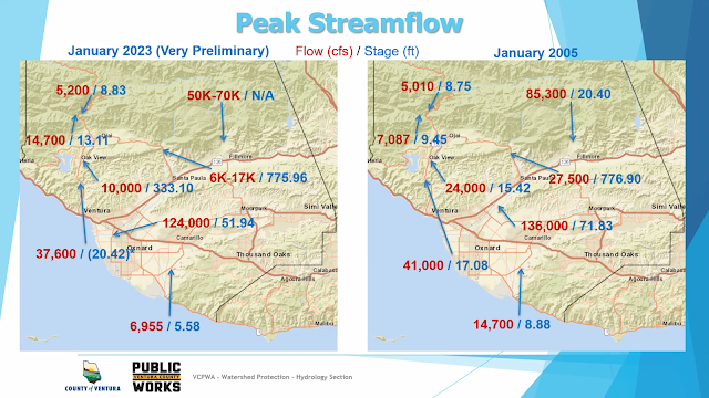
On June 1, WPD hydrologist Scott Holder provided an overview of the flood for the Ventura River Watershed Council. His flow estimates and other data are presented in the slides below:
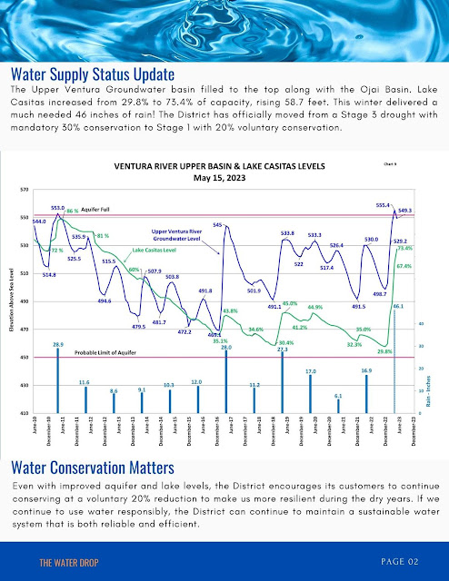
And the Ventura River Water District published their June 1 water supply update showing lake and aquifer levels:
 |


