according to the Ojai Valley News;
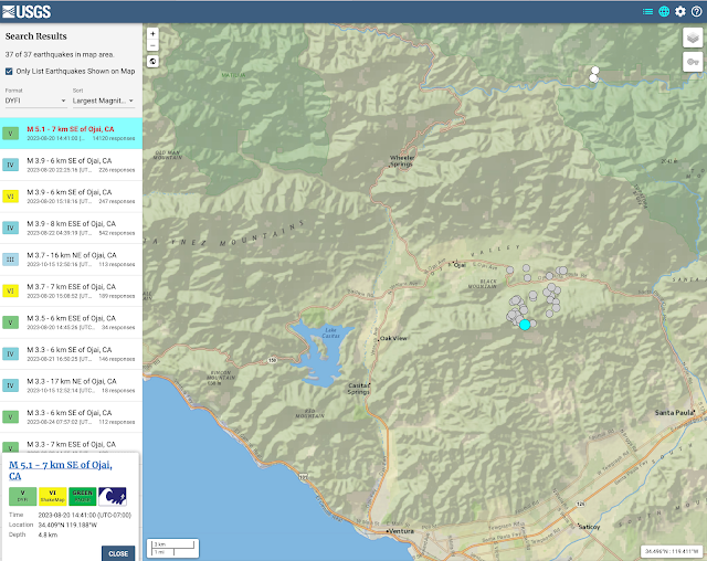
A 5.1-magnitude earthquake struck 7 kilometers southeast of Ojai in the Upper Ojai area near Sulphur Mountain Road at 2:41 p.m. Sunday, Aug. 20, in a huge jolt that shook houses, knocked pictures off walls and sent unsecured household items flying in the Upper Ojai area.
The largest 5.1-magnitude jolt was followed by multiple aftershocks, ranging from 3.7-magnitude to 2.5-magnitude.
At 4:52 p.m. Aug. 20, the Ventura County Sheriff's Office of Emergency Services reported online that the 5.1-magnitude quake occurred on the Sisar fault line southeast of Ojai.
Westridge Market Midtown was closed for about two hours as workers mopped up after bottles broke and spilled all over the floor.
The Sheriff's Office also reported:
— "Casitas and Matilija Dam have been visually inspected by the VC Aviation Unit, with no issues to report. Ongoing inspections by the respective dam operators are underway and will take some time to complete."
 |
| earthquake.usgs.gov |
Aftershocks from the August 20 quake continued through August 24. Another cluster occurred north of Ojai along Sespe Creek on October 15 with the initial shock measured at magnitude 3.7.
Another article published on March 4, 2022 provides more information:
The Feb. 28 and March 1 quakes followed a series of temblors that shook the Upper Ojai area Feb. 26, including a 4.0-magnitude jolt and 21 other small quakes that occurred in the same area Feb. 10 to 16. “Part of the reason that we see so many events now is we have a much better network of sensors out there,”
According to Cochran, there’s nothing to suggest the quakes are related to oil and gas activity in the area. “We would tend to see those be a lot shallower,” she said. USGS recorded the depths of the larger quakes at approximately 15 kilometers, or just over 9 miles. “Those are actually quite deep. They’re the deepest events we typically see in Southern California, in this region,”
The quakes are occurring along the Arroyo Parida Fault, an extension of the Mission Ridge Fault system, said Ed Keller, professor of geology at UC Santa Barbara. It’s uplift along this fault that divided the Ojai Valley into two sections. “The upper and lower Ojai valleys, probably 40,000 years ago, were one valley, and they’ve been separated by the Arroyo Parida Fault, which runs all the way to Santa Barbara,” he said. In the 1980s, Keller did extensive research on the geologic structure of the Ojai Valley. “The Ojai Valley is one of the most seismically active places in California,” he said, due to a high rate of uplift. “The rate of uplift in the mountains is greater here than almost anyplace else I know.” Keller said quakes in the 1.0 to 2.0 range happen fairly frequently, but when they occur in swarms it’s time to be wary.
 |
| Edward Keller Ojai Valley faults map |
References:
5.1-magnitude earthquake, followed by more, hit Ojai area at 2:41 p.m. Ojai Valley News, Aug 20, 2023 Updated Aug 22, 2023
Quakes rattle Ojai Valley, Ojai Valley News Mar 4, 2022


