Wednesday, March 3, 2021

The Story of Our River

Our partners at Once Upon a Watershed have created an informative video telling the story of the Ventura River.  

Once Upon a Watershed provides hands-on local watershed education, restoration and stewardship experience for Kindergarten, 4th, 5th and 6th grade students in the Ventura River Watershed. 

The video shown here was created for their program for 6th grade students which focuses on the critically endangered indicator species, Southern Steelhead Trout, and the effects of the Matilija dam on beach erosion and spawning access.

...the presentation on beaches, sediment, and Matilija dam removal starts around 12:20


More info:

Once Upon a Watershed: Telling the Story of Our Watershed Through Exploration, Education, and Stewardship  https://www.onceuponawatershed.org 

https://www.onceuponawatershed.org/sixth-grade

Watching the Dams Come Down: Nooksack

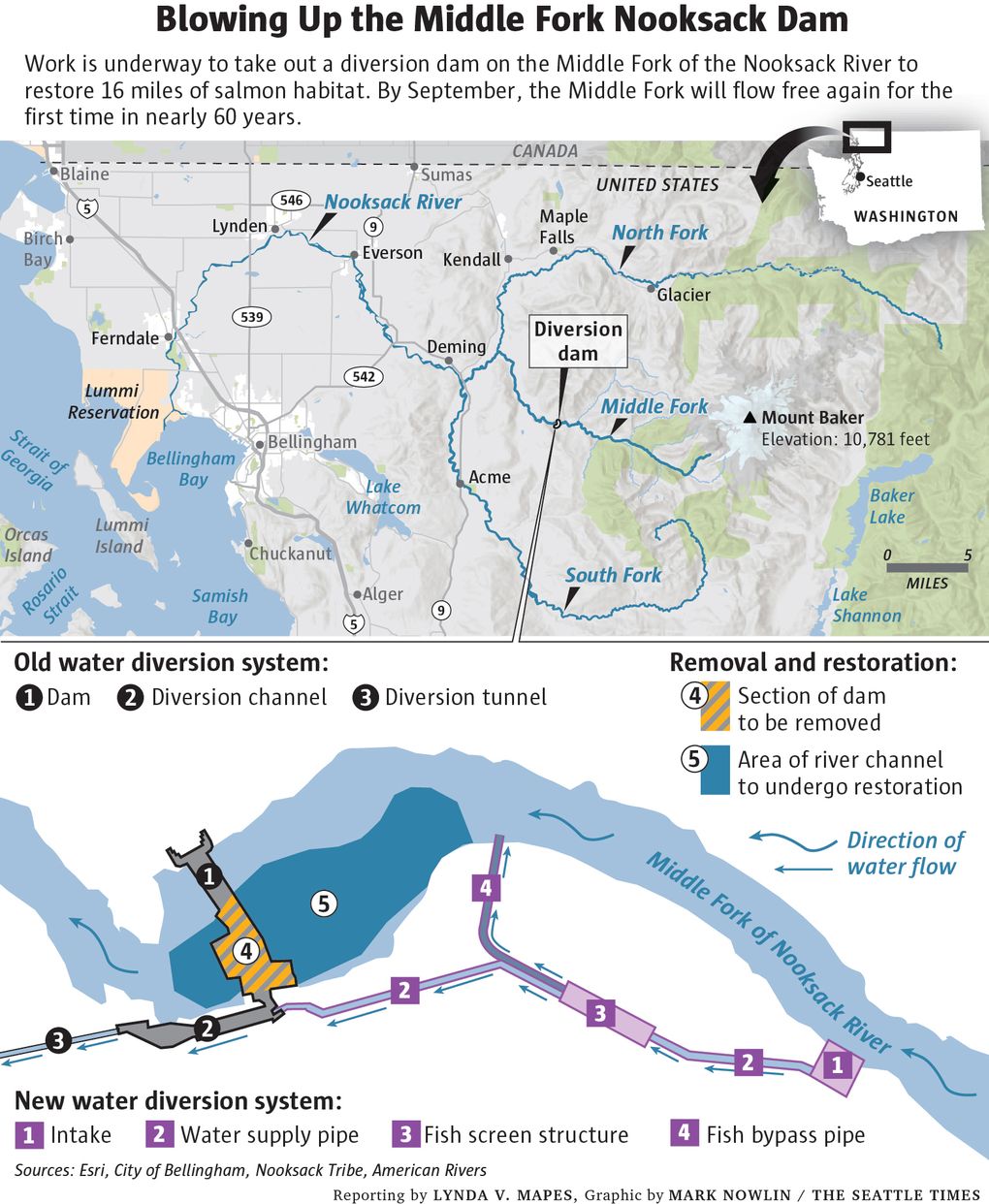
Another dam has been removed in the Pacific Northwest.  We have been watching and learning as our partners on the Matilija Dam project demonstrate success on other rivers.

The Middle Fork Nooksack River Fish Passage project is one of several case studies that has been examined as a strategy for modifying the Robles Diversion Dam downstream of Matilija Dam.  Diversion dams can be particularly tricky as there is a need to not only pass the increased sediment expected with Matilija Dam removal, but also maintain water diversion and fish passage.  In the Nooksack case, this is accomplished by moving water diversion intakes upstream and completely removing the existing diversion dam. 

According to the City of Bellingham, the Nooksack River Fish Passage project will restore access to approximately 16 miles of pristine spawning and rearing habitat in the upper Middle Fork for three Endangered Species Act (ESA) listed Puget Sound fish species: spring Chinook salmon, Steelhead and Bull Trout. Project elements and related benefits include​ moving the point of diversion just upstream of the existing location to eliminate the need for the dam; dam removal and channel restoration to restore habitat connectivity; and installation of fully compliant fish screens for fish protection.


In the news:

Bang! Watch a Nooksack River dam finally coming down, freeing miles for fish habitat, Seattle Times, July 20, 2020


More information:

American Rivers: reimagining-a-river-the-middle-fork-nooksack

NOAA Fisheries: dam-removal-brings-hope-salmon-washingtons-middle-fork-nooksack-river

City of Bellingham: https://cob.org/services/environment/restoration/middlefork


On this blog: 

Watching the Dams Come Down- Elwha

Watching the dams come down - Elwha beaches

Watching the Dams Come Down - Condit

Savage Rapids Dam removed

Klamath Dam removal study supports sediment releases

San Clemente Dam removal

Tuesday, February 23, 2021

Rincon Island decommissioning

Rincon Island, an oil facility off the coast of Ventura County, is being decommissioned by the state. 

https://www.slc.ca.gov/oil-and-gas/rincon-island/


State of California officials say they’ve reached a milestone in the state’s transition away from fossil fuels and toward a clean energy future.

On Feb. 4, the State Lands Commission and the Department of Conservation’s California Geological Energy Management Division announced they’ve plugged and abandoned all 50 oil wells on Rincon Island, a small 2.3-acre artificial island off Mussel Shoals in Ventura County.

Rincon Island is one of a handful of remaining offshore oil structures in state waters, stated the agencies, which also announced the plugging and abandonment of all 24 state onshore production wells, and two additional onshore wells that were not part of state lease operations but had been deserted.

The state took responsibility for decommissioning Rincon in 2017, after the operator declared bankruptcy. It plugged and abandoned the 74 wells ahead of schedule, under budget and without incident or spillage, the Commission stated in a news release.

Plugging and abandoning the wells is the main component of phase one of a three-phase process that includes developing and executing a decommissioning plan. Work on the plan will include extensive public outreach and engagement, according to the Commission.

The remaining phase one work, underway now, consists of site clearance activities to remove decrepit oil production infrastructure and should be completed by June 2021, officials said.

For more information on the Rincon Island decommissioning status and the next steps in the process, visit www.slc.ca.gov/oil-and-gas/rincon-island/.

(article from Ojai Valley News: rincon-island-oil-wells-unplugged


Tuesday, February 16, 2021

Surfers' Point erosion damage Jan 2021


During the first week of February, 2021, the barriers along the eroding coastal path at the Ventura County Fairgrounds were moved back for public safety.  Several more parking spaces have been eliminated as the ocean continues to take back the beach.  


Erosion undermines the bke path,  Jan 13, 2021

This year's damage was more than anticipated, as relatively calm conditions were predicted with "La Nina" conditions dominating the Pacific Ocean.  However, an anomalous storm track developed producing a series of large swell events during the entire month of January, some coinciding with the year's highest tides.  Good for surfers, bad for beachfront property managers.

9 am January 14, 2021
(high tide 6.36 ft @ 9:30 am)

Large swell at Surfers Point, Jan 18, 2021

The final design for "Managed Shoreline Retreat" has been completed, but the process appears to be on hold.   Un-managed retreat continues... Fencing, concrete curb, and asphalt litter the shoreline along the most popular beach in Ventura County.


Overview looking east from the restored beach toward the eroding parking lot
slated for relocation in Phase 2 of the Managed Retreat project

Overview of Surfers' Point looking west - the parking lot in the foreground 
would be relocated out of harms way in Phase 2 of the Managed Shoreline Retreat project 


Artist rendition of the proposed Surfers Point Managed Shoreline Retreat project


Surfers' Point Managed Retreat Phase 1 - Jan 13, 2021
Phase 1 of the project continues to demonstrate resiliency to high surf
(note high tide line and exposed cobble berm)


Update from the City of Ventura:  
The City helped the Fairgrounds remove part of the wood fence, dig out the landscape area, pave the planting or parking area level with the path, and move the temporary fence over for some extra clearance from the eroded area. A few parking spaces had to be taken out to make it safe for pedestrians to pass. The hope is that this is enough to last through the summer, however that is weather dependent.
The City also reapplied for State Parks Division of Boating and Waterways – Public Beach Restoration Grant in the amount of $5.5M last month. This includes the beach side of the $10.1M estimate but not the new paved parking lot, lighting, and other amenities.

On this blog: 


Winter 2021 swells:


Tuesday, December 1, 2020

"Enlivening The Matilija Watershed" Mural

"Enlivening The Matilija Watershed" mural
photo by Rich Reid


Culminating more than a year of planning by Ojai resident Ray Powers, the "Enlivening The Matilija Watershed" mural was revealed in a community celebration on Nov 21, 2020.  The mural was painted on removable panels at the Ojai Unified School District located at 301 N. Montgomery Street in Ojai.

The 30’x14’ mural depicts the Matilija Creek in its regenerated state after the Matilija Dam has been removed. The waters flow clear, the wildlife abundant, the flora and fauna vibrant and renewed. The beaver is featured prominently as it is a keystone species whose presence affects the entire whole of the ecosystem. The mural features the restored watershed which feeds a beaver pond where deer, bear, raccoon, and others come to drink. Oaks, sycamores and willow provide shade and a steady perch for the flyers to come and rest. The steelhead move unimpeded upstream to spawn where once they numbered into the thousands. This pristine and rejuvenated landscape is framed by the cobbled remains of the Matilija Dam which once held back the waters and marred the mouth of the canyon. Its removal signifying the steady return of the natural cycles of life.


The underlying theme of the mural is our role in bringing back the balance of these natural cycles in our ecosystem. The inherent relationship we have as stewards of the land requires reciprocal altruism.  Our ecological behavior and tendencies need to shift to insure the survival of all the native species, which in turn will provide the resources we need to thrive. Environmental education, artistic expression and a vision for the future health of the Ojai Valley watershed are the cornerstone objectives for the “Enlivening the Matilija Watershed” mural. 


Twenty-five students, ages 8-18, participated in the painting with direction from the mural artist. The mural is experienced both as an inspiring piece of art as well as an educational outdoor classroom to teach about environmental sciences and our local watershed. There will be a website devoted to the mural as an “image map” where each graphic element will be clickable with resources to learn more. Signage at the mural site will allow people to access the online image to learn as they look. 


The ceremony began with the mural hidden by a painting of Matilija Dam, which was moved away to reveal the wall-sized mural.  Watch the entire event that included talks by Ray Powers (Artistic Director, Project Manager), Dr. Tiffany Morse (Superintendent, Ojai Unified School District), Marcy Toscher (Chairperson, Ojai City Arts Commission) and Paul Jenkin (Founder, Matilija Coalition / Campaign Coordinator, Ventura Surfrider Foundation).  The reveal begins at 21:22.


Short version with Paul Jenkin and the mural reveal:

Below is a fascinating time-lapse video of the painting process:

This community art project is a partnership between four local artists, Ray Powers (artistic director, project manager, Co-Vice President Ojai Valley Green Coalition), Lisa Kelly (mural artist), Ray Cirino (permaculturist, cob builder, art fabricator) and the Ojai Unified School District (OUSD).  The project is made possible by grants from the City of Ojai Arts Commission and the Resource Legacy Fund. Thank you to the Ojai Unified School District for their in-kind donations and partnership, and the Ojai Valley News for their coverage of the mural creation and reveal celebration.


In the news:
Mural captures vision of restored Matilija watershed, Ojai Valley News, Friday, 06 November 2020
Watershed mural set for big reveal Saturday, Ojai Valley News, Friday, 20 November 2020
Mural reveal wows crowd, Ojai Valley News, Wednesday, 25 November 2020


Friday, October 30, 2020

Surfers’ Point Managed Retreat Phase 2 update

 The final design for Phase 2 of the Surfers Point Managed Shoreline Retreat Project has been completed.  The proposed project will move the fairgrounds pay parking lot back to where Shoreline Drive is today and restore a cobble and sand dune beach as protection for the new parking area.  Unfortunately cost estimates came in at over $10M dollars, around twice the initial estimates.  We are concerned that this high cost may delay construction due to difficulty finding grant funding, but Surfrider will be working with the responsible agencies to determine a path forward.  Stay tuned…

More info here: https://www.venturariver.org/2019/12/surfers-point-phase-2-update.html


Matilija Dam Environmental Review

The Ventura County Watershed Protection District (VCPWA – WP) has initiated environmental review on portions of the  the Matilija Dam Ecosystem Restoration Project (MDERP.)   The updated plan to remove Matilija Dam incorporates new information garnered from recent dam removal projects as well as details regarding proposed modifications to downstream infrastructure. Although environmental review was completed in 2004 as part of the Corps of Engineers planning effort, the VCPWA – WP has determined that preparation of a Subsequent Environmental Impact Report (SEIR) is warranted to evaluate the revised Project. The resulting SEIR analysis will be published next year.

The environmental review will analyze the impacts from the proposed dam removal and the reconstruction of downstream levees and bridges.  Downstream components include the Camino Cielo Bridge, Live Oak Acres Levee, and Casitas Springs Levee.  

Other major downstream components of the project have not yet been adequately designed for this environmental review, and will require future analysis.  These include modifications to the Robles Diversion Dam, 3 miles downstream of Matilija Dam, and proposed flood protection for the Meiners Oaks neighborhood downstream of Robles.


More information on the environmental review process and the project may be found here: https://www.vcpublicworks.org/wp/mderp/

The Matilija Coalition submitted the following comments during the scoping period:

Removal of the Matilija Dam is necessary to reconnect the upper watershed for recovery of the federally endangered steelhead and other species of concern. Dam removal will also renew the flow of nutrients from the ocean and sediment to downstream reaches. In addition to these benefits, the dam currently impacts water quality and quantity and needs to be removed in a timely manner. The growing cost of the project is a barrier to implementation, so cost effective alternatives need to be considered.

Although an EIR is generally intended to address potential negative impacts of a project, the positive outcomes of dam removal should also be analyzed. For instance, it is currently assumed that sediment will have a negative impact to water supply downstream of the current dam site. However, the changes in the watershed following the Thomas Fire demonstrate that increased sediment transport can have a positive effect on water supply. After short term effects on shallow aquifer recharge during the first year after the fire, both surface flows and groundwater levels have responded favorably to the ecosystem changes in the mainstem Ventura river.

The following is an outline of issues and concerns that should be addressed in the SEIR:

1. Baseline conditions

a. Conditions in the watershed have changed significantly since the 2004 EIR, primarily due to the Thomas Fire which burned 95% of the upper watershed and resulted in significant sediment yield and transport downstream.

b. Matilija Reservoir capacity has been reduced to less than 100 Acre Feet, eliminating any meaningful remaining water supply benefit.

c. Total sediment accumulation behind the dam has increased, and the remaining reservoir storage will likely fill with sediment in the next large storm event.

d. The 50-year contractual agreement with Casitas Municipal Water District for operation of the dam ended in 2009.

e. Dam safety concerns have increased. Due to ongoing ASR concrete degradation the dam is categorized high hazard and could fail in an earthquake.

f. Required drawdown has eliminated remaining reservoir storage.

g. Alterations to dam operations since the reservoir was drained in July 2020 significantly impact downstream water quality.

h. The newly exposed fine sediment deposits upstream of the dam show signs of becoming a reservoir for invasive plants, particularly tamarisk.

i. Endangered steelhead populations were severely impacted by fire, and recovery in this watershed is significantly impaired by the presence of Matilija Dam.

j. Steelhead passage at Robles has improved with implementation of a fish ladder.

k. Habitat has improved as a result of invasive species control, including Arundo.

l. Habitat has improved in the mainstem Ventura River with increased sand and gravel deposits originating from effects of the Thomas Fire on the North Fork Matilija Creek.


2. Future without project

a. Sediment accumulation upstream of the dam has accelerated and coarse sediment transport over the dam crest will occur soon.

b. Water quality is impaired by the dam.

c. Endangered steelhead are threatened with extinction in this watershed.

d. Presence of the dam impairs water supply (see 3c below)

e. Existing development in the 100 yr floodplain requires improved flood protection with or without dam removal.


3. Future with project

a. Impacts of sediment discharge should be updated with new information. Since the initial EIR/EIS was developed several large dams have been removed yielding significant information on what may be expected downstream following a natural transport alternative. In every case, the predicted negative impacts did not come to pass, and the benefits far exceeded expectations.

b. Sediment transport and flood analyses should consider realistic scenarios for the assessment of downstream infrastructure.

c. The benefits of renewed sediment transport should be further investigated. Prior analyses focused on fairly abstract assessments of steelhead, riparian habitat, and natural processes. Recent post-fire observations of sedimentation in the Ventura river indicate that there are also tangible water supply benefits including enhanced surface flows and groundwater storage resulting from a restored riparian ecosystem.


4. Alternatives analysis

a. Each project component should include a “no project” alternative as baseline.

b. Mitigation for impacts of levees on riverine ecosystems should be developed in the EIR, including, but not limited to, vegetation, setback alternatives, and other means to minimize the negative effects. Lower cost green/grey and nonstructural alternatives (e.g., reinsurance policies, maintenance funds, etc) should be considered.

c. The cost of the Camino Cielo Bridge includes raising the existing road out of the 100-year floodplain. Cost savings may be had by allowing some level of flood risk during the initial sediment pulse since the few residents that use the road are accustomed to seasonal interruptions to access with the existing culvert crossing.

We hope these comments are helpful in developing the environmental analysis necessary for the removal of Matilija Dam.