Monday, December 18, 2023

Watershed Council Visits Dam

On December 14, 2023, the Ventura River Watershed Council featured the Matilija Dam Ecosystem Restoration Project (MDERP).  This is the biggest project currently underway in the watershed and regular updates have been provided in this public forum over the years.  The meeting included a short presentation and discussion in the Oak View Community Center followed by a guided tour of the dam and surrounds.  The presentation and past meetings can be found here: https://venturawatershed.org/past-meetings

Ventura County has initiated the CEQA environmental review process for the updated plan for dam removal.  Scoping comments are accepted until December 20 at the link above. This meeting gave people an opportunity to see the dam up close and ask questions about planning for the removal of this obsolete structure on the Ventura River.  


Project engineer Kirk Norman presents an overview of the project 

Ventura County biologist and CEQA lead Pam Lindsey discusses Matilija Dam

Ventura County biologist and CEQA lead Pam Lindsey discusses Matilija Dam

Matilija Coalition coordinator Paul Jenkin at Matilija Dam


Friday, December 8, 2023

Watershed Education


OjaiValleyNews.com

For more than a decade, Once Upon a Watershed has provided environmental education to local schools.  The program introduces our watershed to hundreds of students every year both in the classroom and field trips along the river.  This originated from "Once upon a Wetland"  engaging students in hands-on restoration at the Ojai Meadows Preserve and featured in Watershed Revolution.  This locally produced film was aired nationwide on PBS. 

The current program is housed under The CREW, which has secured a permit from County government to take groups of students and others up to the obsolete Matilija Dam.

The tours also help demonstrate why the dam, located on 400 acres owned by the County of Ventura, needs to come down. “The single most important thing for the health of the Ventura River watershed is to remove Matilija Dam,” White said.

Despite the Ventura County Board of Supervisors approving the removal of the dam in 1998, said White, “the fact that we’re still here 25 years later looking at this big slab of concrete is somewhat frustrating.”

Not only does the dam block sediment from moving downstream and replenishing the beaches, it blocks passage of endangered southern steelhead, White told students.

What’s more, sediment backfilling the dam has tailed back so far that, in places, it’s actually made the creek higher than the access road into the canyon. “So whenever there is a flood the road gets taken out,” White said, “and that’s problematic for the people who are living in Matilija Canyon, because it’s one road in and out.” During January’s heavy downpours, residents had to be flown in and out of the canyon by helicopter.

Nearly all the public schools Once Upon a Watershed works with are Title 1 schools, “which indicates they’re in a disadvantaged or low income community,” said White, who takes fourth-, fifth- and six-graders to different places in the watershed. “We’re based in Ojai and so we run programs primarily in the Ventura River watershed.”

Once Upon a Watershed is funded by grants and operates on an annual budget of approximately $100,000, White said. OVS has been highly supportive of the program, he added.

“It’s such an important thing for young people to understand where our water comes from,” said sixth-grade teacher Ryan Lang, who grew up in Matilija Canyon and still resides there.


Once Upon a Watershed website features an interactive image map


Link to: 

Once Upon a Watershed mural

Watershed Revolution film 

Oak Grove School - Sixth Grade Trip to the Dam


On this Blog:

Watershed Revolution

Once Upon a Watershed

The Story of Our River

Salmon Run 2016

Ojai Meadows Preserve

Matilija Dam Student video - Merito Foundation program


In the News:

Lessons at the Dam, by Perry Van Houten, Ojai Valley News,  Nov 9, 2023 Updated Nov 13, 2023   

Friday, December 1, 2023

Headwaters to Ocean (H2O) Conference

The California Shore and Beach Preservation Association (CSBPA) and Beach Erosion Authority for Clean Oceans and Nourishment (BEACON) organized the 2023 Headwaters to Ocean (H2O) Conference.  This was the first big in-person gathering of professionals involved in watershed and coastal  health, restoration, and management since the COVID pandemic.

On Tuesday November 28, BEACON convened their science advisory panel and stakeholders for a morning meeting followed by lunch and guided tour of the Surfers' Point Managed Shoreline Retreat Project.  

H2O was a two day conference held in the Crowne Plaza Hotel on Ventura Beach on November 29-30. 

The H2O conference serves as a catalyst for collaboration across various fields, industries, institutions, and organizations united by their shared interests in topics related to water, oceans, coastal environments, sediment management, resilience, and the intersections between terrestrial and marine systems.  

A session on Surfers' Point included presentations from Paul Jenkin, Surfrider Foundation, Bob Battalio, ESA, Dave Hubbard, CRC, and Kiki Patsch, CSUCI.  The talks covered the history, engineering, dunes, and monitoring.


Paul Jenkin presented the lunchtime plenary talk, "A Lifetime of Coastal Activism; A Retrospective" or "Headwaters 2 Ocean; Ventura River, a Case Study"


H2O Conference Website: https://asbpa.org/2023/08/15/h2o-2023-conference/


Monday, October 30, 2023

Matilija Dam Geology

A 2007 presentation for the annual meeting of the Association of Environmental and Engineering Geologists provides an overview of the geologic setting of Matilija Dam.  The presentation illustrates the presence of geologic faults and foundation problems with the dam.


The presentation also includes a description of the alkali aggregate reaction that compromised the strength of the concrete and led to the 1965 "notching" to lower the dam crest.


The complete talk may be downloaded here:

THE CASE FOR REMOVING MATILIJA DAM, J. David Rogers, Ph.D., P.E., P.G. University of Missouri-Rolla and G. Mattias Kondolf, Ph.D. University of California, Berkeley, Annual Meeting Association of Environmental and Engineering Geologists, Los Angeles, California September 28, 2007 


On this blog:

Grand Jury on Dam Safety

Matilija Reservoir Drained

Thursday, October 26, 2023

Earthquakes in the Ojai Valley


according to the Ojai Valley News;

A 5.1-magnitude earthquake struck 7 kilometers southeast of Ojai  in the Upper Ojai area near Sulphur Mountain Road at 2:41 p.m. Sunday, Aug. 20, in a huge jolt that shook houses, knocked pictures off walls and sent unsecured household items flying in the Upper Ojai area.

The largest 5.1-magnitude jolt was followed by multiple aftershocks, ranging from 3.7-magnitude to 2.5-magnitude.

At 4:52 p.m. Aug. 20, the Ventura County Sheriff's Office of Emergency Services reported online that the 5.1-magnitude quake occurred on the Sisar fault line southeast of Ojai.

Westridge Market Midtown was closed for about two hours as workers mopped up after bottles broke and spilled all over the floor.

The Sheriff's Office also reported:

— "Casitas and Matilija Dam have been visually inspected by the VC Aviation Unit, with no issues to report. Ongoing inspections by the respective dam operators are underway and will take some time to complete."
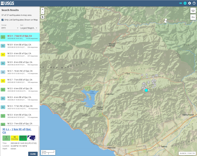

earthquake.usgs.gov

Aftershocks from the August 20 quake continued through August 24.  Another cluster occurred north of Ojai along Sespe Creek on October 15 with the initial shock measured at magnitude 3.7.

Another article published on March 4, 2022 provides more information:

The Feb. 28 and March 1 quakes followed a series of temblors that shook the Upper Ojai area Feb. 26, including a 4.0-magnitude jolt and 21 other small quakes that occurred in the same area Feb. 10 to 16. “Part of the reason that we see so many events now is we have a much better network of sensors out there,”

According to Cochran, there’s nothing to suggest the quakes are related to oil and gas activity in the area. “We would tend to see those be a lot shallower,” she said. USGS recorded the depths of the larger quakes at approximately 15 kilometers, or just over 9 miles. “Those are actually quite deep. They’re the deepest events we typically see in Southern California, in this region,”

The quakes are occurring along the Arroyo Parida Fault, an extension of the Mission Ridge Fault system, said Ed Keller, professor of geology at UC Santa Barbara. It’s uplift along this fault that divided the Ojai Valley into two sections. “The upper and lower Ojai valleys, probably 40,000 years ago, were one valley, and they’ve been separated by the Arroyo Parida Fault, which runs all the way to Santa Barbara,” he said. In the 1980s, Keller did extensive research on the geologic structure of the Ojai Valley. “The Ojai Valley is one of the most seismically active places in California,” he said, due to a high rate of uplift. “The rate of uplift in the mountains is greater here than almost anyplace else I know.” Keller said quakes in the 1.0 to 2.0 range happen fairly frequently, but when they occur in swarms it’s time to be wary. 

Edward Keller Ojai Valley faults map


References:

5.1-magnitude earthquake, followed by more, hit Ojai area at 2:41 p.m. Ojai Valley News, Aug 20, 2023 Updated Aug 22, 2023  

Quakes rattle Ojai Valley, Ojai Valley News  Mar 4, 2022


Friday, October 20, 2023

Elwha, Dam Removal Success Story

A decade after the removal of two high dams on the Elwha River, scientists are documenting the recovery of an entire ecosystem.  The science bodes well for the recovery of the Ventura River ecosystem with the removal of Matilija Dam.

This PBS documentary tells the story: 

Undamming a river, rebuilding a forest | WILD HOPE

"Ten years after the largest dam removal in history—on the Elwha River, in Washington State—scientists are chronicling an inspiring story of ecological rebirth. Recovering salmon populations are transferring critical nutrients from the ocean into the forests along the Elwha’s banks, enriching the entire ecosystem. The Elwha’s revival is encouraging advocates to push for the removal of many larger dams in the region, and in the rest of the world."


More on this blog:  Elwha


Thursday, October 12, 2023

Surfers' Point Nature Based Solutions video


"Fighting Climate Change with Nature," a video produced by the Surfrider Foundation featuring the Surfers' Point Managed Shoreline Retreat project:


Thursday, June 1, 2023

Surfers' Point funding ok'd

 At the June 1st meeting of the California Coastal Conservancy the board approved $16,200,000 to the City of San Buenaventura (Ventura) to construct Phase 2 of the Surfers Point Managed Retreat Project, a sea level rise adaptation project that relocates existing infrastructure landward and restores beach dune habitat, in Ventura. 


Surfrider submitted a support letter saying:

Surfers’ Point has been the flagship campaign of the Ventura County Chapter of the Surfrider Foundation since its inception in 1991.  For more than 30 years our members have advocated for the community-based solution to coastal erosion offered by this project.  The construction of the first phase in 2011 has proven the efficacy of this approach and we look forward to completing the project.  In recent years the rapid loss of the remaining bike path and parking lot has increased the urgency to relocate this visitor serving infrastructure out of harms way.  Implementation of the proven buried cobble berm and sand dunes will restore nature-based resiliency to this extremely popular stretch of coast.

Construction will begin after Labor Day, 2024


On this blog: Surfers Point


Reference:

COASTAL CONSERVANCY Project No. 08-057-02 Staff Recommendation June 1, 2023


 In the News:

Ventura gets $16M to move crumbling path, parking lot farther from crashing waves


Tuesday, May 23, 2023

Klamath River dam removal begins


After nearly two decades of planning, construction recently began on the estimated $450 million Klamath River Renewal Project.  The project involves the simultaneous removal of four dams to restore the second largest river in California.  The project is overseen by the independent nonprofit Klamath River Renewal Corporation formed in 2016 to navigate the complex regulatory and legal issues associated with dam removal.


ASCE provides a good technical summary of the project here:  Construction begins on removal of 4 Klamath River dams.  In 2009 we noted that Klamath Dam removal study supports sediment releases, and each of the four dams will utilize natural transport for disposal of the majority of the fine sediment that has accumulated in the reservoirs.  Most of the concrete and other materials will be disposed at or near each of the dam sites.  

The Klamath River suffered a dramatic and notorious fish kill in 2002 when over 34,000 fish, mostly adult fall Chinook salmon, were found dead in the Lower Klamath River. This fish kill was unprecedented for returning adult salmon on the Klamath River, profoundly affecting the Yurok People and other local residents both economically and spiritually.  The river suffered another fish kill following the fires of 2022.  The major contributing factor to unhealthy fisheries in the Lower Klamath River has been the presence of the large reservoirs which accumulate agricultural runoff and fertilizers which heat up in the hot summer months and fuel toxic algae.  Removal of these dams will eliminate the release of this toxic hot water into critical salmon habitat.  Most importantly this project will restore one of the most productive salmon runs in California to benefit the Native American communities who have depended on fisheries for their livelihood, health, and cultural practices since time immemorial. 

Also of interest is the The Klamath Mitigation Fund which "is a voluntary claims-based compensation program in which impacted property owners can participate.  The Fund is designed to provide compensation for specified physical impacts to private properties caused by the Klamath dam removal project. The Fund will be administered by independent Fund Administrators based on criteria established from extensive technical analysis. The Fund Administrators will organize information sessions by potential claim (slope stability, flood risk, and groundwater well impacts) to explain the analysis and approach. They will ultimately make independent compensation decisions and manage settlements with individual property owners for physical damages demonstrated to be caused by dam removal. Such payments (which will settle claims) will avoid the need for litigation to resolve such damages.”


In the news:   

First Klamath River dam to be removed by end of summer  

The massive dam removal on the Klamath may save salmon but can’t solve the West’s water crisis

With one down, Klamath dam removal proceeds on schedule

An Important Milestone on the Klamath – Removal of the Copco 2 Dam Complete! American Whitewater11/09/2023


On this blog:

Klamath Dam removal study supports sediment releases


Reference:

Klamath River Renewal Corporation

Klamath Mitigation Fund

Construction begins on removal of 4 Klamath River dams, ASCE 5/11/2023

The Klamath River Fish Kill of 2002 CA.gov 

Klamath River Fish Kill 2002 (Earthjustice) - YouTube video


Thursday, April 27, 2023

Ventura Water Pure Ocean Outfall

The City of Ventura is planning to construct an ocean outfall extending approximately 6,800 feet offshore from Marina Park near the Ventura Harbor.  The outfall and associated pipeline will ultimately serve to dispose of concentrated "brine" from the planned "Ventura Water Pure" wastewater recycling facility.    A new underground pipeline will connect the existing Ventura Water Reclamation Facility to the outfall.  


Initially the City will discharge up to 4.7 million gallons per day (MGD) of tertiary-treated water through the ocean outfall. The Ventura Water Reclamation Facility currently discharges tertiary-treated wastewater into the Santa Clara River Estuary (SCRE) near its connection to the Pacific Ocean.  In March 2010, the Ventura Coastkeeper and Heal the Bay filed a lawsuit alleging that the discharges of the tertiary-treated effluent into the estuary violated State and Federal law.  The City settled and entered into a consent decree requiring the City to develop alternatives that would improve conditions for the habitats and species within the estuary.  The first phase would discharge up to 90% of the City's treated wastewater offshore by 2030.  

The City is also currently planning for the Ventura Water Pure reclamation facility which would further process the tertiary wastewater using reverse osmosis and other treatments to allow injection into local aquifers.  This would provide a new source of water through Indirect Potable Reuse (IPR) to help accommodate the City's growth.  The byproduct of this process is a concentrated "brine" which will be disposed offshore through the ocean outfall.  


Construction will mainly impact Marina Park and the harbor area to install the plumbing necessary to disharge offshore as shown in the illustration below. A 20-inch diameter high-density polyethylene (HDPE) Conveyance Pipeline will connect from the wastewater treatment plant at Harbor Boulevard and Olivas Park Drive, extending north along Harbor Boulevard, then west on Schooner Drive, and northwest along Anchors Way where it would connect to the Harbor Crossing. The 20-inch pipe will be bundled with two 8-inch sewer pipes in a 36" pipe to be drilled 30 feet below the harbor bottom to connect with the Ocean Outfall at Marina Park.  


The City completed their environmental analysis of this project in 2019 with an addendum in 2022.  


BACKGROUND AND ANALYSIS:

Surfrider has advocated for water recycling over the past decades, and this ocean outfall is a necessary component of this.  Recycling is accomplished by reverse osmosis which generates a “brine” that has to be disposed of.  Once the WaterPure facility is operating this outfall will be primarily for brine disposal.  In the interim, while the facility is being constructed, the outfall will be used for offshore disposal of tertiary treated wastewater.  This would effectively relocate the disharge from the estuary/nearshore to a mile offshore in Pierpont Bay to comply with a court order resulting from Wishtoyo/HealtheBay lawsuit.
Some of Surfrider's prior comments on this issue are here: https://www.venturariver.org/search?q=scre

There are some unavoidable impacts with this project, but in the long term it should lead to improvements in our regional water supply and water quality as well as eliminating the impacts to the Santa Clara River Estuary.  Concerns include whether offshore currents could bring the effluent back onshore and of course the implications of sea level rise.   Coastal Commission Staff recognized the sea level rise concerns by reducing the permit from 50 yr to 30 yr at which point they would revisit it.

A big concern is the City's ambition that this outfall could one day be used for an intake of ocean water for desalination.  Surfrider and others have concerns about ocean desalination due to the impacts on the marine ecosystem and the carbon footprint of this energy intensive process.  


IN THE NEWS:

California's Ventura Gets $173M in EPA Loans for More Resilient Water Supply, ENR, May 24, 2023

Key funding comes through from EPA to boost water supply in Ventura, VC Star, May 24, 2023

Ventura has been awarded federal loans covering half the costs for a program to convert treated wastewater into safe drinking water and reduce discharges of effluent into the Santa Clara River estuary.

Speaking at a news conference Tuesday at the city's water reclamation plant, officials said the venture will benefit the environment, boost water supplies by up to 20% and protect the community against drought.

The financial award is a "monumental milestone," Ventura Mayor Joe Schroeder said at the invitational event where federal, state and city officials celebrated the nearly $174 million in funding and promoted the benefits of the project called VenturaWaterPure.

The loans will pay for half of the $354 million to be spent on an initial phase, program Director Linda Sumansky said. Around 60% of the roughly 5.5 million gallons of treated effluent going into the estuary daily will be diverted and an advanced purification plant built. A second phase allowing all the effluent to be diverted will cost another $80 million.


REFERENCE:


Ventura Water Pure: https://www.cityofventura.ca.gov/1646/VenturaWaterPure
Library of Documents: https://www.cityofventura.ca.gov/1685/Library-of-Reports

Pending permit applications include:

California Coastal Commission: Staff Report, Exhibits
State Lands Commission:  Staff Report


Friday, March 10, 2023

Santa Ana Bridge Replacement

On October 17, 2022 Ventura County Public Works Agency (VCPWA) hosted a ribbon cutting ceremony to celebrate the official opening of the new Santa Ana Boulevard Bridge.  This bridge is the first major infrastructure component of the Matilija Dam Ecosystem Restoration Project, and was deemed necessary due to existing deficiencies in the height and length of the bridge.  The new bridge is 50 percent longer than the old bridge, an increase that will partially restore the Ventura River’s natural channel capacity. 

The bridge was replaced to widen the river and eliminate the "bottleneck" at this location to better pass flood flows.  Widening the river at this location will improve natural sediment transport and migration habitat for the federally-endangered southern California steelhead and other species. 

The first test soon came with the flood of January 9, 2023.  Flood waters passed freely beneath the new bridge, while the old bridge may have backed up flows and potentially sustained damage.  

Santa Ana Bridge - the recently replaced bridge during the flood of Jan 9 2023
photo: Rich Reid


Santa Ana Bridge - the recently replaced bridge during the flood of Jan 9 2023
Photo: Ventura County


Diagram illustrates how the replacement Santa Ana Bridge widens the Ventura River

Overhead view of the new Santa Ana Bridge, Jan 2023


Aerial view looking upstream at Santa Ana Bridge during construction 10-9-21


The bridge replacement was planned to minimize disruption to local traffic by constructing the new bridge upstream before switching traffic and demolishing the old bridge.  Funding was provided through a grant from the CA Dept of Fish and Wildlife, and construction was completed on schedule before this historic wet winter.


The new Santa Ana Bridge following the flood of Jan 9, 2023


In the news:

Santa Ana Bridge expansion will help with dam removal, Ojai Valley News June 14, 2019


New bridge is one more step toward goal of dam removal, Ojai Valley News Oct 13, 2022


Aerial photos courtesy Rich Reid rich@richreidphoto.com


Friday, February 24, 2023

More funding for Matilija Dam

On February 16, 2023, the state Wildlife Conservation Board approved a $4.3 million grant to the Ventura County Watershed Protection District for a planning project that will complete final design plans for Matilija Dam removal.  Since 2016, the Matilija Coalition has assisted the County with successful grants totaling over $36 million for the project. Although there is much work to be done, including construction of downstream bridges, levees, and water supply infrastructure, this grant creates a path to be prepared for dam removal by 2030.

Meanwhile, this year’s significant winter floods have moved large quantities of sediment down Matilija Creek, almost completely filling the obsolete reservoir with sand destined for the beach.


Sedimentation in Matilija reservoir 2-11-2023


More info:


In the news:


On this Blog:


Surfers Point in the news

 Ventura made the news recently with the headline “Here's how one beach in Ventura County is trying an innovative strategy to combat erosion

February 17, 2023, VENTURA, Calif. (KABC) -- The severe storms that hit California this season could end up costing the state in excess of $1 billion.

Coastal communities seem to move mountains in an effort to slow the beach erosion that threatens life near the ocean. But about 10 years ago, Surfer's Point in Ventura County became the site of a test for a managed-retreat strategy as the best way forward.

"It's really the nature-based solution and finding ways to work with nature so that people can still access this area," says Bill Hickman, Southern California regional manager for the Surfrider Foundation.


Building on the success of the first phase of the project, the City of Ventura has submitted a grant application to pay for the construction of the $16 million “Phase 2” Managed Shoreline Retreat.  The project will relocate the damaged Fairgrounds beach parking and bike path and restore the shoreline with a protective cobble beach and dunes.  The State Coastal Conservancy will make a decision this summer.  


Wednesday, February 8, 2023

January 2023 Flood Overview

Aerial images provide perspective on how the Ventura River responds to flood.  The wide floodplain is typical of high sediment yield watersheds, featuring braided channels that shift with each major flood event.  The flood of January 9, 2023 ripped out large areas of vegetation and "re-set" the floodplain.   These images were taken shortly after the storm and are organized downstream to upstream. 


Ventura River near Foster Park - flows overtopped the bank near the City of Ventura Nye Wells


Flooding near Foster Park - several homes were damaged 

 
Ventura River near Oak View - stream bank erosion damaged the Ventura River Trail and broke the main sewer line - combined with a similar broken line on San Antonio Creek 14 million gallons of sewage were estimated to have spilled into the river closing beaches for more than a week

Ventura River downstream of Santa Ana Bridge

Ventura River at Santa Ana Bridge - the bridge was recently replaced widening the river to accommodate high flows and future increased sediment transport with Matilija Dam removal

Live Oak levee upstream of Santa Ana Bridge - similar damage occurred in the 2005 flood - this levee is currently in final design for reconstruction as part of the Matilija Dam Ecosystem Restoration Project

Ventura River at Highway 150 bridge

Ventura River above Highway 150
the Ventura River Preserve protects open space for recreation and  natural floodplain management 

Robles Diversion - the flood filled the forebay with sediment and breached the timber cutoff wall
Casitas Municipal Water District quickly implemented emergency repairs to restore water
 diversions to Lake Casitas

 
Ventura River upstream of Robles Diversion
stream bank erosion exposed and broke the Matilija Conduit which supplies Casitas water to property owners upstream

Ventura River near Ojala - this view looking upstream includes Matilija Canyon and Matilija Dam - flood flows severely damaged the Camino Cielo crossing which provides access from Highway 33 to several properties - a new bridge is being designed as part of the Matilija Dam Ecosystem Restoration Project


Photo published in the Ojai Valley News shows the extent of debris flows on Highway 33 - the Highway was closed indefinitely for repairs 


Damage to Highway 33 along North Fork Matilija Creek - photo published by CalTrans


(all photos courtesy Rich Reid rich@richreidphoto.com except where noted)


Hindsight Analysis of the 2023 Flood


Forecasters predicted 8 inches of rain for the January 6 storm.  However, after the first 8 inches accumulated on already saturated ground another 8 inches fell in less than 8 hours on the ridges and in Matilija canyon.  The the third in a succession of atmospheric rivers, this storm ultimately delivered over 18 inches to the steep mountains of the Ventura River watershed.


The USGS flow gage at Foster Park is the primary indicator for flood flows on the Ventura River.  This hydrograph includes the upstream USGS gage below Matilija Dam.  Unfortunately neither of these gages measured the peak of the flood on January 6.

Ventura County Watershed Protection District provides a chart with flood impacts expected for specific flows at certain gages.  The chart below shows these impacts for the Foster Park gage.


Extrapolating these impacts it is reasonable to assume that with the closure of Highway 101 Foster Park probably experienced peak flows over 40,000 cfs.  According to the USBR chart below this corresponds to perhaps a 20 year event in the lower part of the watershed.

However, based upon Casitas Municipal Water District reports of over 23,000 cfs at the Robles Diversion it is likely that the upper watershed experienced a 50-year event.  This would be consistent with the damage experienced in Matilija Canyon and along Highway 33, which is likely to remain closed for a year.  (The last time the cutoff wall at Robles Diversion failed was 1969.) 

Note that Watershed Protection estimates that damage to the homes near Foster Park would not occur until the 60,000 cfs flow level.  As illustrated in the photos above this year's flooding did impact those residents suggesting that possibly vegetation and debris backed up flows under the Casitas Vista bridge below Foster park.  This neighborhood was recently removed from the FEMA 100-yr floodplain.

Also note that, as predicted, flows over 25,000 cfs resulted in damage to the Ojai Sanitation District sewer line along the bike path.  (Another sewer line also failed on San Antonio Creek along with significant property damage in that tributary.)  

The flood of January 6, 2023 was a historic event with significant impacts to infrastructure and property in the Ventura River watershed.  (The chart below was compiled before the 2005 flood)


On June 1, WPD hydrologist Scott Holder provided an overview of the flood for the Ventura River Watershed Council.  His flow estimates and other data are presented in the slides below:


And the Ventura River Water District published their June 1 water supply update showing lake and aquifer levels: